

Optimised seismic data – with RQC

In order to achieve the best quality seismic data, recording instrumentation and seismic sources should perform as per their manufacturer’s specifications.
Seismic recording instruments have built in diagnostic software to check system integrity and run a suite of tests to check the status of the ground equipment.
The instrumentation is also capable of monitoring Vibroseis and explosive source attributes to ensure the quality of the generated seismic signal meets client and industry standards.
Offering stability in turbulent times
It is very apparent, however, that the situation in the world is currently far from normal. The profitability of oil companies is based on the price of oil which is very much dependent on world demand. Fluctuations in world demand are strongly influenced by world economic conditions and any downturns in the world economy enforce oil companies to re-evaluate their business models and cut costs to maintain profitability for their shareholders. The Covid-19 pandemic, for example, resulted in an economic downturn of extreme proportions.
SeisTrain offers SeisTrain RQC (Remote Quality Control) as a significant cost saving option to companies to check the technical performance of a seismic crew without the need to employ a qualified CSR in the field. SeisTrain RQC provides companies with access to experienced CSRs located remotely from the seismic crew who can verify the technical integrity of the seismic recording operation using Seismatters QC software either daily of periodically as per client requirements. All that is needed is internet connectivity capable of transferring files output by the recorder between the seismic crew and the remote CSR for analysis and return of the results.
Savings, analysis, verification
Remote QC offers three key benefits to companies:
As an alternative to employing a full-time technical CSR in the field to analyse daily data, thus reducing consultancy costs.
For third party periodic analysis of, for example, monthly instrument and vibrator tests.
An experienced team of specialists for every project, delivering expertise from initial project outline to completion.
SeisTrain RQC focuses on providing detailed analysis of seismic source attributes, recording instrumentation and sensor daily tests, evaluation of noise sources on the recording spread, vibrator similarity analysis, and analysis of monthly or periodic instrument tests.

Vibrator status reports are typically output from recording systems as “vaps” txt files. Remote analysis of these files using Seismatters VAPSDB3 software either daily or periodically as preferred allows an experienced CSR located anywhere in the world to identify and report any issues with vibrator performance that may need investigation on the seismic crew.
VAPSDB3 is a very comprehensive leading edge software package that provides detailed analysis for every possible aspect of vibrator performance. Attributes that are analyzed include: Average and Peak Phase, Average and Peak Distortion, Average and Peak Force, Stiffness, Viscosity, and Overload and Warning errors for Mass, Baseplate, Force, Pressure and Valve.
Other analyses include COG positioning errors, dynamic slip time analysis, source and fleet pattern analysis, VP rate, vibrator availability and access to historical data. If there are any problems with a vibrator they will be identified by VAPSDB3.
Using a selection of Seismatters programs including SLX2 and SMRefract to analyse daily test files a remote CSR can identify any issues with the ground equipment (cables, geophones, nodes, etc.) and report these issues back to the seismic crew immediately for investigation.
These programs are designed primarily to flag recording channels that are out of specification for ease of identification rather than give a full breakdown of the instrument test results.
Using Seismatters program PN2 which analyzes data recorded in the daily receiver noise test files a picture of all extraneous noise on the recording spread can be produced.
By combining noise data from a number of days a remote CSR can identify fixed, long term noise sources as opposed to transient noise sources that are localized and only present for a few shots e.g. a light vehicle crossing a line.
Significant long term noise sources could be detrimental to the overall data quality and should be evaluated and noted for processing and interpretation purposes. Feedback from periodic analyses of field spread noise can be provided to the seismic crew.
As well as monitoring real time performance of vibrators it is important to compare the actual Vibroseis signal ground response with the Pilot or Reference sweep.
This is called a Vibrator Similarity and is the definitive test of vibrator performance.
In the field you would typical run Wireline Similarities and Independent Accelerometer test systems such as Testif-I on all vibrators monthly, and when a vibrator has undergone major repairs.
Output files from similarity tests run in the field can be sent to a remote CSR to process and check the data using Seismatters SMSim3 software and thus provide the client and the seismic crew with a detailed report on the status of the vibrators.
Output files from similarity tests run in the field can be sent to a remote CSR to process and check the data using Seismatters SMSimProcessing and analyzing the results of recording system instrument tests is necessary to ensure correct system performance, irrespective of whether these are daily, monthly or project startup acceptance tests.
Although recording systems run their own set of tests it is a common requirement these days to independently analyse the tests using third party software to verify the integrity of the manufacturer’s software. SeisTrain RQC provides Seismatters SITA program for this purpose.
Instrument test output files can be sent to a remotely located experienced CSR to process the tests and provide a detailed test report of the results to the client and seismic crew.
In addition to the programs mentioned above Seismatters also provides the following for remote QC: a) software for storage and display of SMT geophone test results; b) SEGD and SEGY header scanners and viewers; c) display panel software with filter and scaling parameters useful for parameter test analysis.
3 software and thus provide the client and the seismic crew with a detailed report on the status of the vibrators.
Using SMRefract is a fully featured viewer that allows for refraction calculations to be carried out on seismic data records as well as picking breaks. The program handles all types of SEGD inputs, including Nodal.
As well as the shot display and a filter capability the program can also show the FFT of a selected zone, full spread status, selected traces from anywhere on the record, decoded headers, line profiles along with the identification of weak and noisy traces.
It also allows for the CSR to maintain a database which tracks failures which can be provided to the client and seismic crew to ensure continued quality of the data. SeisTrain RQC is a one stop solution to verify the technical performance of a seismic crew using leading edge QC software by a qualified CSR located anywhere in the world.
For further information on SeisTrain, get in touch today.
More from GEo Resources
The GRCSeisQC™ program enables the remote quality control of 2D/3D/ Vibroseis with an internet connection from anywhere in the world, our proprietary software provides detailed analysis of the acquisition system components, vibrator performance analysis to include similarity processing along with a detailed daily, weekly and monthly report to the client. The daily report includes easy visualisation of graphs to clearly show out of spec channels, equipment and vibrators along with the recommended action to be taken to rectify issues.
SMRefract is also part of the suite and is a multi-featured QC tool which allows for viewing of refraction statics as well as shot display and filter capability. SMSim3 Vibrator Similarities Analysis program processes and analyses vibrator similarities. Vibrator similarities compare the actual Vibroseis signal ground response with the Pilot or Reference sweep and are the definitive test of vibrator performance in all terrain types.
The GRCSeisQC™ system reduces the overall risk of personnel exposure in the field, whilst maintaining the highest possible data integrity from anywhere in the world.
Seismic exploration is the single and most important geophysical technology in the exploration for energy resources. A successful seismic survey is dependent on the overall quality of the acquired seismic data, and our highly professional project managers and technical client representatives are committed to achieving the best possible results. We work closely with the client and contractors to achieve operational excellence with full adherence to HSSE in every aspect, from project inception to completion and beyond.
All GRC specialist consultants follow a strict code of professional conduct, exhibiting and upholding professional and personal integrity at all times, ensuring compliance with all relevant legislation and regulations in all countries where we operate.

GRC provides Health, Safety, Security and Environmental QC Specialists for Land, Marine and Transition Zone projects, with worldwide experience and a proven track record in any environment. All of our specialists are highly qualified to Internationally recognised standards, with a minimum of 15yrs experience within the industry to meet the client’s health, safety and environmental objectives which are critical to project success.
In addition to Health, Safety and Environmental, our specialists will advise on local security and propose management guidelines as appropriate to our clients.
HSE Awareness and training is at the forefront of GRC’s vision, and our specialists will provide training courses to the contractor’s own personnel as part of their project assignment if required.
As part of GRC’s own HSE MS we will request a feedback questionnaire from all clients on our consultants HSSE awareness and contribution as part of the service provision, ensuring a consistent approach to providing the best possible service, adding additional value to any project.

The SeisTrain™ course is designed to train personnel in the methods, skills and attributes required for the competent quality control of the data acquisition of a seismic exploration project, operating on either land or marine using multiple acquisition techniques. It also covers the basics of HSE Management systems specific to seismic operations which often take place in remote environments.
Technically the course covers all aspects of seismic acquisition using the latest technology, so that trainees understand the full acquisition process from survey positioning through to in-field data processing using the latest acquisition technology, to include Drones and Nodal sensors. Training is ‘hands on’ and requires that trainees be fully committed to both theory and practical tasks.
The training program, being modular in nature, allows for progressive development as operational conditions permit and can be tailored to be flexible to the needs of the client. The training can be utilised on both Land, TZ and Marine seismic projects and is aimed at training on the very latest technology.
A short introductory video on the training program and structure can also be found by visiting our website at www.seistrain.com further demonstrations can be provided upon request.

All drivers shall demonstrate minimum competencies which will be of a high standard (enquire for regional specifics), with learning materials available in different languages.
Training will be a hands-on site-based learning experience, designed to enhance individual on and off-road driving skills.
- Involvement in proactive HSE adherence and the reporting of incidents.
- To demonstrate the use of a GPS to navigate, enter waypoints, track-log and to understand how to setup a GPS (basic).
- How to check the vehicles (Daily Checks/Importance of) and to report defects.
- To safely change a vehicle tyre and how to identify issues with tyres, tyre inflations, wear, minimum standards etc
- How to use a standard GRC vehicle checklist to periodically inspect the vehicle OR with the company’s own Inspection checklist (to be provided to the DDT)
- How to utilise the GRC HSE Inspection App to carry out vehicle inspections (to be provided to the DDT).
- The use of IVMS, and its importance to control driving behaviours.
- Night Driving on crews that operate 24hrs, the hazards and required skills to safely navigate during the hours of darkness.
- Demonstrate the use of a vehicles off road capabilities
- Demonstrate the use of various forms of recovery equipment and how to apply different techniques to situations
- To effectively describe the requirements and preparation for travelling to/from the field (JMP) and its adherence.
- Monitor driving on and off-road conditions
- Manage a work team carrying out recovery procedures
- Reinstate equipment/vehicle systems at the end of recovery operations
- Describe potential dangerous operating condition where recovery may be required
- Respond to driving/recovery-related emergency according to individual company procedure
The application allows the user to perform safety inspections on a handheld device, and works on all iPhone, IPad and Android devices.
The inspections cover all aspects of seismic activities, including vehicles, camps, camp electrics, workshops and offices, as well as seismic operations in the field.
The inspections can be connected to the client’s own database for inspection results in real time and instantly generates reports online and in PDF and can be adapted to the needs of the clients.

We at GRC International believe that a Survey QC is paramount in ensuring that your seismic survey is carried out accurately, on budget and on time, providing our client with a high degree of confidence that their survey data has been produced to the highest possible standard.
The scouting of any project is critical for the competence of the crew. If HSE events can be anticipated and mitigated in advance, then lives can be potentially saved; for example, preventing the rollover of vehicles and vibrators working in difficult terrain on 24 hour per day operations.
GRCProjectScout™ is GRC’s comprehensive seismic project scouting service that identifies and advises on unforeseen circumstances in any area and in any terrain, to identify and reduce HSE and business risk.
The scouting of any project is critical to evaluate the performance and efficiency of the crew. Before embarking on a scouting project, we consider all the possible factors based on the terrain, infrastructure and the environment. A terrain model using the best available satellite imagery and DEM data is produced and used as the first step to evaluate the terrain classification and expected project HSE risks.
Once the basic lay of the land has been identified a full-scale field scout should be carried out. We can provide experienced professionals to carry out such a scout but ideally, they should be accompanied by client and contractor representatives if available at the time. The purpose of the field scout is primarily to confirm the pre-determined terrain classification but should also be used to identify a number of other project specific details including:
• Stakeholders requiring engagement
• Permitting and local community issues
• Emergency response and nearest medical facilities
• Security issues
• Potable water sources
• Fuel supply
• Sewage and waste disposal facilities
• Location of possible camp sites
• Areas where a PTW is required
• Communications, availability of GSM signal, need for Vsat
• Infrastructure details that could affect the survey such as pipelines, oil field facilities, overhead powerlines, construction activities, etc.
After completion of the scout, GRC will provide a full scout report to the client and contractor detailing all the findings and recommendations.
The technical ability of a seismic crew, in terms of instrumentation and personnel, is critical to the success of a seismic exploration program, but this is not the whole story.
A crew cannot work without adequate resources to support the data acquisition process. This is usually provided by a base camp with accommodation and an operational infrastructure which should not only be sufficient to support the crew but should also meet established industry standards for HSE and remote facilities.
In addition to GRC Intl’s Technical Audit package for independently verifying the recording instrumentation, GRC Int’l also offers the GRCTechInsp™ Seismic Crew Technical Inspection Service to check a seismic crew’s overall readiness to start field operations. This readiness review can be an integral part of a client’s pre-startup crew acceptance process.
Seismic crews these days can vary in size considerably from small compact crews shooting 2D seismic lines through jungles and forests to mammoth size crews of 1,000+ personnel shooting huge 3D surveys across vast deserts. The HSE and operational resources required for these differing size crews can therefore vary significantly, but irrespective of the size the standards should always be same.
At a minimum the standards should meet client and/or industry specifications for the size of crew provided and support required. Clients very often provide their own contractual specifications for HSE, operations, camps and facilities based usually on local regulations and international standards.
At a minimum these will meet the standards established by the IOGP (International Association of Oil & Gas Producers). If a company does not provide its own specific documentation then standards should meet those of the IOGP.

On surveys that require advance work remote from base camps or have difficult access to work areas that would require very long travel to and from the work site, seismic crews often deploy localized fly camps to support the operation in such situations. The standards for fly camps should be no different to those of base camps. Fly camp inspections can also be carried out as part of the GRC Int’l inspection service if requested by a client.
The purpose of GRC Intl’s Seismic Crew Technical Inspection Service is therefore to check the readiness of a crew to start work. This involves inspecting all aspects of the crew and the camp to check adequate equipment and facilities are available, equipment is fit for purpose, personnel are trained accordingly for all job tasks, and the work can be carried out safely and efficiently. Fixing problems prior to startup is far easier than fire-fighting once recording has started. Inspections and verifications will be measured against the specifications and standards contractually required by the client
Vehicle Inspection Brief
It is very common these days for seismic crews by necessity to operate a large fleet of vehicles in order to work efficiently.
This is particularly the case for crews working on large scale desert projects in the Middle East where the total number of light and heavy vehicles can be in excess of 200. Keeping fleets of this size operational is a major task and requires comprehensive maintenance schedule planning with extensive facilities and qualified personnel to carry out the service and repair work.
In some countries the minimum standards required with regards to the safety of land transport in Oil & Gas operations are well defined and documented, and controlled by regulatory boards and the traffic laws of the country. In other countries there is very little regulatory control but ideally clients should have similar in-house standards that contractors are required to follow to ensure the integrity and operation of their vehicle fleet.
Where minimum standards are regulatory controlled, the standards will often include a number of aspects of vehicle safety that all contribute to minimizing the risk of a road traffic accident (RTA). These are typically broken down into 3 categories: 1) Driver, 2) Vehicle and 3) Monitoring and Management System.
Driver
For the type of vehicle intended to drive, drivers should be eligible, licensed, qualified, trained and medically fit. The driver should also understand the rules of the road whether this be blacktop or off-road.
Driver requirements will vary depending on vehicle type and environment with more specific requirements required for heavy vehicle drivers, bus drivers, ambulance drivers, vibrator drivers, and heavy plant (bulldozers, graders, etc.) drivers.
Vehicle
Vehicles must be licensed, fit for purpose and capable of working in the terrain encountered in seismic exploration prospects.
Minimum vehicle standards should include generic requirements for all types of vehicle plus other requirements specific for the type of vehicle and the working environment, for example: 4WD vehicles, heavy vehicles, tankers, trailers, buses, vibrators, emergency vehicles, heavy plant, etc. In some countries the requirements are referred to as a Roadworthiness Assurance Standard.
New vehicles should meet this and once operational all vehicles should be maintained to this level, verified by regular inspections and serviced as per manufacturer’s recommendations.
Monitoring and Management System
The purpose of a Monitoring and Management System is to ensure that rules of the road are being followed and adhered to, and that drivers are driving safely and defensively. It is therefore recommended that vehicles are fitted with an IVMS (In-Vehicle Monitoring System) to record a driver’s performance, and that a robust Journey Management System is in place to track all vehicle trips.
It should be noted that the above standards should be applicable for all vehicles related to a seismic operation irrespective of whether the vehicles belong to the seismic contractor, subcontractors or service providers.
For the most part the benefit to both clients and contractors of having a fleet of fit for purpose vehicles in good working condition driven by qualified drivers is clear. Well maintained, roadworthy vehicles driven safely and closely monitored will inevitably result in fewer RTAs. Sufficient vehicles will always be available to meet operational requirements thus ensuring a smooth running, efficient project with no downtime or lost productivity due to vehicle shortages. Safety and productivity run hand-in-hand.
GRC International offers a Vehicle Inspection service to check and verify all of the above, thus providing clients with a high degree of confidence that all land transport related issues are fully addressed and of an acceptable standard. Inspections can be tailored to fit regulatory criteria or otherwise depending on client requirements and specifications.
Inspections will by necessity include physical vehicle checks using comprehensive checklists (tablet based and database linked), review of vehicle maintenance schedules and records, driver training and qualification checks, and review of IVMS and Journey Management implementation and data.
All GRC International consultants have at least 15 years’ experience in seismic exploration with a thorough knowledge and understanding of land transport safety. GRC International is also happy to advise, recommend and propose methods to check contractors fleet management systems if clients do not have their own specificstandards in place.
The goal is to achieve an RTA frequency rate of Zero.
Seismic exploration is the single and most important geophysical technology in the exploration for energy resources. A successful seismic survey is dependent on the overall quality of the acquired seismic data. Professional project management of the survey is a key component of this, and GRC Int’l can provide highly competent and well qualified individuals for this purpose.
Project management is the practice of leading the work of a team to achieve goals and meet success criteria at a specified time. The primary challenge of project management is to achieve all of the project goals within the given constraints. The primary constraints are usually scope, time, quality and budget. Ideally the project manager should be on-board pre-project start up, acting as the link between the client and contractor, so that communication protocol is clearly identified and issues can be discussed and addressed expeditiously between all parties.
The objective of project management is to produce a complete project which complies with the client’s objectives. In many cases the objective of project management is also to shape or reform the client’s brief to feasibly address the client’s objectives. Once the client’s objectives are clearly established they should influence all decisions made by other people involved in the project – for example project managers, designers, contractors and sub-contractors. Ill-defined or too tightly prescribed project management objectives are detrimental to decision making.
All GRC Int’l project managers have at least 15 years’ experience in seismic exploration with a thorough knowledge and understanding of the business. Their experience includes managing seismic acquisition projects for numerous major, national and independent oil and gas companies. They work closely with the client and contractors to achieve operational excellence with full adherence to HSSE in every aspect, from project inception to completion and beyond.
All GRC specialist consultants follow a strict code of professional conduct, exhibiting and upholding professional and personal integrity at all times, ensuring compliance with all relevant legislation and regulations in all countries where we operate.
In order to facilitate safe and efficient operations in rugged and mountainous environments, GRC mountaineers and steep terrain specialists can provide the expertise necessary to help clients achieve this.
They have extensive experience working on geophysical surveys around the globe and clients will benefit from a suite of services they can provide including in-depth scouting reports, detailed project hazard and terrain analyses, and tailor made risk assessments.
Pre-task evaluation, and identifying and training of competent crew personnel capable of working in such environments are also critical aspects of the job provided by the specialists.
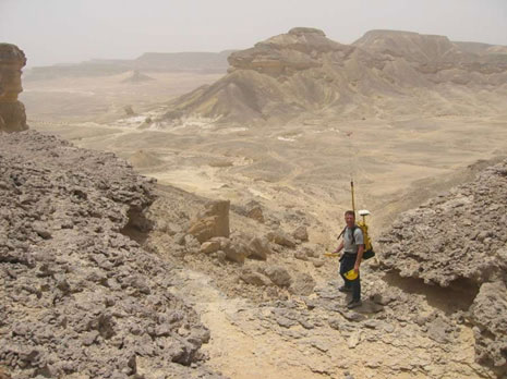
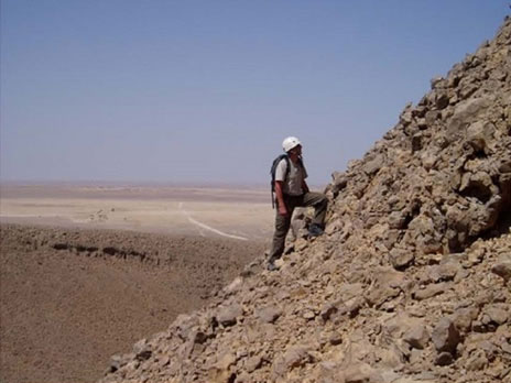
In the field, GRC mountain specialists acting in a field supervisory role work proactively to optimize crew performance and reduce the risk of incidents.
If accidents do occur they can integrate readily into existing Emergency Response Plans and teams, being familiar with mountain search and rescue procedures. Many of our specialists are also Advanced First Aiders able to immediately respond to emergency medical situations should they arise.
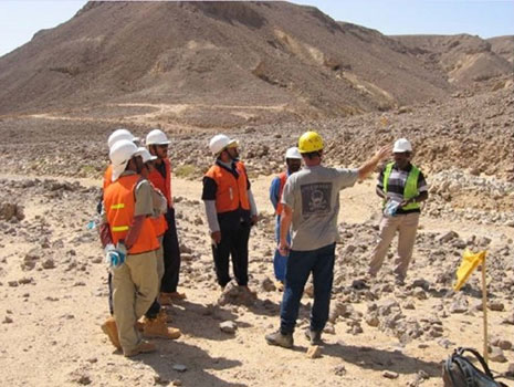

In extremely steep terrain, mountaineers using specialized equipment can assist in survey and recording operations to ensure that skipped points are minimized and the subsequent loss of data quality is reduced as much as possible.
It is highly likely that in such extreme terrain the work must be carried out only by specialist mountaineers as exposure to crew personnel with inadequate training would be too risky and dangerous.
One of the critical tasks of mountaineers is to identify these specific zones as part of the terrain assessment. Factors that affect these decisions include slope steepness, rock quality, fall hazard potential, weather, heat, water and repeated use of routes.
Mountaineers must be prepared to re-classify terrain on a regular basis and any safety concerns that result from changing terrain conditions would be discussed in all safety orientations.

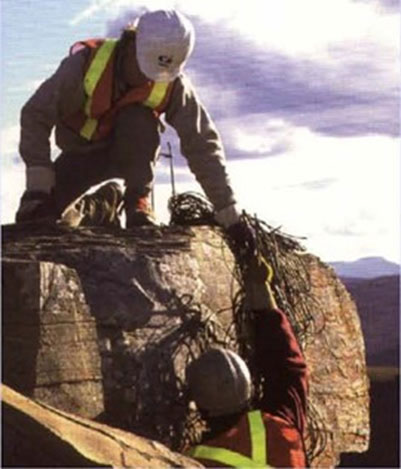
As geophysical operations in mountain regions can potentially impact the environment in these sensitive areas, GRC mountain specialists can advise on best practices to minimize this and are fully conversant with IOGP guidelines designed to reduce the environmental footprint caused by seismic activities in these regions.